TRANSPORTATION AND LOGISTICS
Traffic – safe and efficient with MetGIS

Weather data is critical to the transportation and logistics industry. It affects operations, traffic control, route planning, and helps adapt to climate change. From avoiding weather-related disruptions to supporting intelligent transportation and IoT applications, accurate weather forecasts provide a significant advantage. Discover how MetGIS can help you increase efficiency and reduce risk.


Weather has a significant impact on the transportation and logistics industry because it can affect operations. Weather-related interruptions and disruptions to infrastructure (road, rail, airports and seaports) lead to delays, breakdowns, accidents and sometimes loss of goods. The result is higher costs and more planning. In the worst-case scenario, deliveries and emergency vehicles may be lost or lives put at risk. Accurate weather data and forecasts are therefore a key competitive advantage to ensure efficient and orderly operations.
More frequent extreme weather events caused by climate change will have a major impact on the transportation and logistics sector. To reduce the risk to employees, machinery and goods, it is important to be prepared. The resulting technological shift towards green technologies is an additional challenge. Again, the weather factor should be taken into account to enable more efficient operations and make a valuable contribution to the green transition.
Effectively regulating traffic depends on numerous data points and variables, including meteorological data. The primary objective is to ensure traffic safety, which necessitates the availability of adequate information in a timely manner. This allows for the effective management of traffic volume to avert potential hazards. Even minor traffic congestion can lead to substantial problems and risks.

Weather data is crucial for winter and summer service, as it allows for the targeted use of gritting material, reducing fine dust pollution and the excessive use of salt on roads. The concentration of the salt solution must be adjusted according to the temperature. Storms, snow loads, ice formation due to freezing rain, hail and heavy rain leading to mudslides can significantly impact road safety. Efficient deployment planning is essential for managing economic resources, including minimizing the number of gritting vehicle trips and optimizing personnel scheduling, such as on-call times during weekends. Precise weather data facilitates cost reduction and enhances road safety.
Weather data is a critical component of intelligent transportation systems. It facilitates the optimization of traffic flows, enhances vehicle safety, and assists in route planning. Adaptive traffic light control systems, driver assistance systems and autonomous vehicles utilize weather information to ensure safe and efficient traffic management. Furthermore, weather data plays a crucial role in maintenance planning, snow clearance, and emergency management, contributing to the development of a more sustainable and secure traffic infrastructure.

Weather conditions play a crucial role in route planning and our system can issue alerts in advance to warn users about potential hazards such as heavy snow or strong winds. This allows users to plan alternative routes and avoid potentially dangerous passages, ensuring a safe and comfortable journey.
Powerful AI models present a variety of opportunities to enhance traffic management and promote public safety. The role of weather conditions in affecting particulate pollution and air quality in urban areas is particularly significant, given its impact on human health.
Prevailing weather conditions have a significant impact on the efficiency of electric vehicle routes. Meteorological data plays a crucial role in supporting autonomous vehicles and assistance systems by providing vital information about road conditions. This enables vehicles to adapt their driving style or display warning messages in a timely manner, ensuring safety and optimal performance under diverse conditions. In this area, the potential for innovation by developers is limitless. MetGIS is well-equipped to provide weather expertise and data to support your innovation project.
![]() Premium weather data: up to 30 meters resolution
Premium weather data: up to 30 meters resolution
We are proud to combine innovative weather models with precise terrain data, which is integral to the high quality of our forecasts. This claim is supported by verification studies that have been conducted on several continents since 2007.
 Expert hotline
We don’t hide behind contact forms or chatbots! If you would like to talk to us, simply call us directly. Our meteorologists and IT professionals will be happy to help you on +43 1 890 90 32.
 Test without obligation with Developer Key
See the precision of our weather data for yourself how easy it is to integrate it into your website, app or business application. Follow these steps to test our API for 30 days at no obligation.

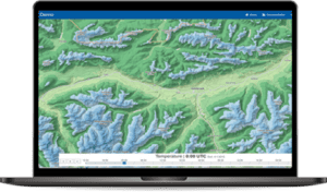
Our solution for a simple and graphically appealing presentation of weather data is the MetGIS Pro+ weather dashboard. This innovative tool provides clear and elegant visual representations of various weather variables, eliminating the need for programming expertise or specialized meteorological knowledge. It offers a comprehensive overview of the current weather situation, enabling users to make informed decisions quickly and efficiently. Convince yourself of the quality and possibilities of our weather dashboard by taking a look at our online demo.
MetGIS Pro+ combines numerous advantages in one user-friendly application – no programming skills needed!
Simply connect APIs without technical expertise. All information is presented graphically, allowing you to leverage MetGIS’ extensive expertise and experience in an intuitive GUI interface.
MetGIS Pro+ is your ready-to-use solution for weather data – simple, efficient and effective.

Professional API with ultra-precise weather forecasts for the whole world, accurate to 30m.
High-resolution weather layers for existing maps (e.g. Google Maps) or area forecasts.

Weather data from the past with extremely high resolution.
Do you have questions about our services or any other questions, simply fill out the contact form or send us an e-mail.
We also look forward to your call.

Meteorologe, Entwickler des Designs des MetGIS Prognosesystems
Curriculum vitae
This will close in 0 seconds
This will close in 0 seconds