Energy
MetGIS weather data for energy providers – focus on renewable energy sources

In the current energy landscape, wind, sun, and water are gaining significant prominence in the realm of electricity production, playing a pivotal role in the ongoing energy transition. These sustainable sources are a driving force behind the progress of this transition. The predictability of power generation relies heavily on weather patterns. MetGIS offers precise weather data, enabling efficient management of production and accurate prediction of fluctuations. Rely on our extensive array of weather parameters to establish a solid foundation for your own energy production. Our weather data is not only available for future predictions but also in hourly grids for historical analysis, making it ideal for training AI models.

![]() WATER POWER
WATER POWER
![]() SOLAR ENERGY
SOLAR ENERGY
![]() WIND ENERGY
WIND ENERGY

Accurate forecasting models are essential for effective planning and management of solar energy generation. The variability of solar radiation necessitates precise forecasts to ensure grid stability. Many countries have legal obligations to report the amount of electricity fed into the grid in advance. Accurate weather forecasts are also increasingly important, especially in the context of energy communities. MetGIS provides reliable data to optimize planning and enhance the efficiency of solar systems. Key meteorological parameters include air temperature, cloud cover, wind strength and various radiation parameters, particularly global radiation.
MetGIS weather data allows you to leverage natural forces to strategically plan hydropower production and minimize the risks to your facilities posed by extreme weather conditions. Hydropower relies heavily on favorable weather conditions. By integrating high-resolution meteorological models with topographical models, MetGIS provides distinct advantages for this purpose. In addition to providing precise precipitation forecasts, we specialize in calculating detailed information regarding fresh snow, temperature, and snow line. This allows us to differentiate between rain and snowfall over catchments, enabling precise runoff prediction.
This information is crucial for flood mitigation and for understanding long-term runoff trends. For instance, a snowy winter indicates ample water for the melting period, which is a key parameter for energy production. Additionally, we provide real-time satellite-based data on snow cover as part of our service portfolio. Our data is frequently utilized as input for hydrological models, such as runoff models. These models are partly provided by our customers and partly by our partner companies.


Accurate wind information is essential for the planning and operation of wind farms. Since wind characteristics vary at different heights, specialized weather data is necessary to make the best use of wind turbines. MetGIS provides stable and accurate wind data for efficient utilization of wind as a natural resource. We have the capability to do this because we operate closely meshed atmospheric models that incorporate high-resolution terrain data. Our comprehensive wind information, available at various sea levels, encompasses mean wind speed, wind direction, and wind gusts, ensuring our clients have the data they need to make informed decisions.
PRECISE WEATHER INFORMATION
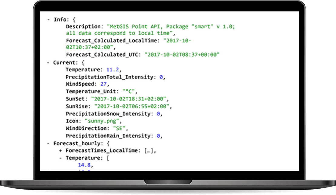
The MetGIS Point API is a reliable and powerful solution for querying point-based weather data. Via the API we offer a variety of weather parameters, which are available in different output formats.
The API can be integrated into your application quickly and easily.
HIGH-RESOLUTION WEATHER LAYERS
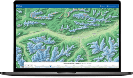
Our Maps API makes it easy to integrate weather data into external information systems and platforms that are based on the Tile Map Service (TMS) standard.
The weather information can thus be placed as a “color layer” over background maps such as Google Maps or OpenStreetMap.
HISTORICAL WEATHER DATA WITH THE HIGHEST PRECISION

MetGIS provides an extensive set of historical weather data.
To generate the data, we went beyond the usual standard.
Our approach not only includes global weather reanalysis models, but also integrates information from regional simulation models and measurement series from certified weather stations.
WEATHER FORECASTS FOR THE FUTURE

The MetGIS Long Range Forecast API relies on ensemble modeling. For this purpose, different forecasts (“ensemble members”) are used and compared with each other. The accuracy of weather predictions is directly related to the number of ensemble members who predict a certain weather situation.
MetGIS is able to recognise trends and forecast probabilities, and make these available to you.
High-resolution and interactive

MetGIS Pro+ is your ready-to-use solution for weather data – simple, efficient and effective. This interactive, advanced dashboard bundles high-resolution weather and snow information into one easy-to-use application. All information is presented graphically, allowing you to leverage MetGIS’ extensive expertise and experience in an intuitive GUI interface.
Daily weather reports in your email inbox

The MetGIS Weather PDF Report is a straightforward, ready-to-use solution that automatically notifies you on a one-time or recurring basis regarding the weather forecast for the coming days. It presents all significant meteorological details in a compact, graphically designed PDF format, incorporating embedded forecast information in a compact, easy-to-understand layout. It enables rapid and straightforward comprehension of current and future weather conditions.
![]() Premium weather data: up to 30 meter resolution
Premium weather data: up to 30 meter resolution
We are proud to combine innovative weather models with precise terrain data, which is integral to the high quality of our forecasts. This claim is supported by verification studies that have been conducted on several continents since 2007.
 Expert hotline
We don’t hide behind contact forms or chatbots! If you would like to talk to us, simply call us directly. Our meteorologists and IT professionals will be happy to help you on +43 1 890 90 32.
 Test without obligation with Developer Key
See the precision of our weather data for yourself how easy it is to integrate it into your website, app or business application. Follow these steps to test our API for 30 days at no obligation.
Do you have questions about our services or any other questions, simply fill out the contact form or send us an e-mail.
We also look forward to your call.

Meteorologe, Entwickler des Designs des MetGIS Prognosesystems
Curriculum vitae
This will close in 0 seconds
This will close in 0 seconds