Civil protection and disaster control
Risk assessment for natural disasters

Given the unavoidability of extreme weather events, such as heavy rainfall (often associated with flooding and/or mudslides), heavy snowfall (often triggering avalanches), temperature extremes (causing natural phenomena such as forest fires) or severe storms, it is essential to carry out a risk assessment using weather forecasts and solid meteorological data. Doing so will help to minimize the consequences and effects and reduce the risk for emergency services.


The quality of weather data is of crucial importance, especially when it is necessary to react to unforeseen events. For example, in the event of heavy rainfall, weather forecasts make it possible to estimate how the weather situation will develop and how much water can be expected. Such information enables the implementation of appropriate protective measures.
Our innovative and high-resolution weather models provide emergency services with the latest and most accurate weather information, enhancing their safety and reducing damage to deployed (recovery) equipment.
In addition to providing highly detailed weather forecasts, MetGIS offers historical weather data and climate data with exceptional resolution, making it especially valuable in times of climate change. This data helps estimate the frequency of extreme weather events, including maximum values that can be expected within a certain period of time (annualities). Such information is essential for planning protective measures against natural disasters.
Those in charge of civil protection and disaster control can better plan and act proactively thanks to our specialized tools and analyses.

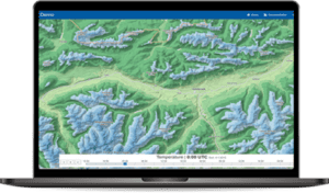
Our solution for a simple and graphically appealing presentation of weather data is the MetGIS Pro+ weather dashboard. This innovative tool provides clear and elegant visual representations of various weather variables, eliminating the need for programming expertise or specialized meteorological knowledge. It offers a comprehensive overview of the current weather situation, enabling users to make informed decisions quickly and efficiently. Convince yourself of the quality and possibilities of our weather dashboard by taking a look at our online demo.

MetGIS Pro+ combines numerous advantages in one user-friendly application – no programming skills needed!
Simply connect APIs without technical expertise. All information is presented graphically, allowing you to leverage MetGIS’ extensive expertise and experience in an intuitive GUI interface.
MetGIS Pro+ is your ready-to-use solution for weather data – simple, efficient and effective.

Professional API with ultra-precise weather forecasts for the whole world, accurate to 30m.
High-resolution weather layers for existing maps (e.g. Google Maps) or area forecasts.

Weather data from the past with extremely high resolution.
![]() Premium weather data: up to 30 m resolution
Premium weather data: up to 30 m resolution
We are proud to combine innovative weather models with precise terrain data, which is integral to the high quality of our forecasts. This claim is supported by verification studies that have been conducted on several continents since 2007.
 Expert hotline
We don’t hide behind contact forms or chatbots! If you would like to talk to us, simply call us directly. Our meteorologists and IT professionals will be happy to help you on +43 1 890 90 32.
 Test without obligation with Developer Key
See the precision of our weather data for yourself. And how easy it is to integrate into your website, app or business application. Follow these steps to test our API for 30 days without obligation.
Do you have questions about our services or any other questions, simply fill out the contact form or send us an e-mail.
We also look forward to your call.

Meteorologe, Entwickler des Designs des MetGIS Prognosesystems
Curriculum vitae
This will close in 0 seconds
This will close in 0 seconds


