WEATHER APIs
MetGIS weather data APIs – precise weather parameters for every application

MetGIS offers a wide range of weather APIs for decision-makers, agencies, developers, and anyone else who needs professional weather data for their applications.
Our APIs deliver ultra-accurate weather data with a resolution of up to 30 meters. This allows users to access specific weather data for various locations, even those just a few meters apart. Integrating MetGIS weather data into applications is easy with our comprehensive, user-friendly documentation.
The data can be accessed via simple HTTPS requests in various formats, allowing for seamless integration with your preferred application.
 For websites, apps and business applications
 Ultra-precise weather data with a resolution of up to 30 m
 Available worldwide, even for remote regions
 APIs for forecasts and historical weather
![]() Point and area queries
Point and area queries
 Reliable and highly resilient
![]() Simple integration & multilingual support
Simple integration & multilingual support
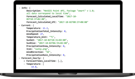
The MetGIS Point API provides reliable weather data for any location using latitude and longitude coordinates. It contains a wide range of weather data, including temperature, precipitation, wind speed and direction, humidity, cloud cover, and sunshine duration. This data is available in JSON and CSV formats.
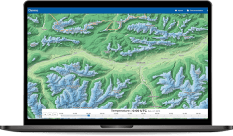
The MetGIS Maps API provides exceptional graphical representation of high-resolution weather data down to 30 meters, spanning from narrowly defined areas to large regions. This feature enables users to swiftly and reliably access a comprehensive spatial overview of various weather parameters.
The data can be seamlessly integrated into customers’ geographic information systems via background maps such as Google Maps or Open Street Map.
We offer data in UTC grids, an efficient and space-saving coding method for map-based data. This method is particularly suitable for area calculations and combined weather maps, for example for cloud cover, rain, and snow. Applications such as precipitation forecasts, hydrographic services, and snow cover modeling benefit greatly from the accuracy of our data.
MetGIS Maps API is a valuable resource for accessing precise and comprehensive weather data presented in map form.

MetGIS’s Hist API provides access to high-precision historical weather data, with a resolution of several 100 meters that allows for the identification of weather patterns in even the smallest spaces.This extensive data set is essential for a wide range of applications, including strategic planning, decision-making, and AI projects.
The historical weather data from MetGIS helps optimize resource allocation, minimize costs, and mitigate risks. Explore how the Hist API can empower you to proactively prepare for potential events. The MetGIS historical weather data API is more than a conventional tool, it’s a gateway to a future of enhanced situational awareness and enhanced safety.
The MetGIS Long Range Forecast API provides long-term weather forecasts up to seven months in advance, based on ensemble models. It provides probabilities for weather parameters, such as temperature and precipitation, and enables a daily or monthly resolution. The API is suitable for various industries, including agriculture, tourism, energy, and logistics. It is available worldwide and can be easily integrated into existing systems, with data in JSON format.

Weather portals and apps | News and tourism websites | Energy: solar, wind, hydro
Big data and machine learning | ad/campaign management | digital services
Agriculture | Transportation and logistics | Severe weather warnings | Events | and much more!
 Snow
Snow
For ski resorts, slope management and everyone involved with snow and mountains.
 Energy
For weather-optimized solutions in the energy sector and associated software and apps.
 Agricultural sector
For farms and smart farming.
 More
More
For weather apps/portals, start-ups, retail, web agencies, tourism, etc.
![]() Premium weather data: up to 30 m resolution
Premium weather data: up to 30 m resolution
We are proud to combine innovative weather models with precise terrain data, which is integral to the high quality of our forecasts. This claim is supported by verification studies that have been conducted on several continents since 2007.
 Expert hotline
We don’t hide behind contact forms or chatbots! If you would like to talk to us, simply call us directly. Our meteorologists and IT professionals will be happy to help you on +43 1 890 90 32.
Test without obligation with Developer Key
See the precision of our weather data for yourself. And how easy it is to integrate into your website, app or business application. Follow these steps to test our API for 30 days without obligation.
Do you have questions about our services or any other questions, simply fill out the contact form or send us an e-mail.
We also look forward to your call.

Meteorologe, Entwickler des Designs des MetGIS Prognosesystems
Curriculum vitae
This will close in 0 seconds
This will close in 0 seconds