Snow and winter
Extremely detailed snow cover and fresh snowfall maps

On this page you can learn more about the innovative solutions of MetGIS for accurate snow cover and fresh snow mapping. MetGIS combines high-resolution satellite data with proprietary weather models to produce detailed snow cover maps with an accuracy of up to 30 meters. Our fresh snow maps allow you to accurately predict the amount of snow that will fall over different periods of time.
You can integrate this valuable snow data and other winter weather parameters into your applications using the MetGIS Maps API and Point API. This will provide you with a comprehensive view of the current snow and weather conditions in your area.
![]() Ultra-precise snow cover maps for important mountain ranges (Alps, Pyrenees, Andes …)
Ultra-precise snow cover maps for important mountain ranges (Alps, Pyrenees, Andes …)
 Fresh snow maps for various forecast periods. Worldwide, even for remote regions.
![]() Special parameters such as wet bulb temperature, felt temperature, fresh snow density, freezing rain and much more
Special parameters such as wet bulb temperature, felt temperature, fresh snow density, freezing rain and much more
 Extremely high horizontal resolution of up to 30 m
 Information available via Point API, Maps API and the MetGIS Pro+ dashboard

In cooperation with the Deutsches Zentrum für Luft- und Raumfahrt/German Aerospace Center (DLR), MetGIS has developed special techniques to generate daily updated snow cover maps for alpine regions (Central Europe, Southern Andes, Pyrenees, …). The maps can be zoomed to any level of resolution up to 30 meters. The unique feature of the MetGIS snow cover maps is not only the extremely high resolution and full zoom capabilities, but also the use of satellite data (Sentinel-2, MODIS) combined with our high resolution weather model.
Due to cloud cover, ground information from satellites is often not available. During long periods of bad weather, satellites alone would not provide up-to-date snow cover. By combining satellite data with our own high-resolution weather model, our data is always up to date and can be updated more frequently.
Snow cover maps can be integrated into third party applications via MetGIS Maps API or queried as an integrated solution via MetGIS Pro+.
![]() TYPE OF MAP
TYPE OF MAP
Snow cover (master map, combines all sources)
Snow cover (information only from Sentinel-2 satellite)
Snow cover (information only from Modis satellite)
Age of snow information
Source of snow cover information
REGIONS
Central Europe
Pyrenees
Southern Andes
 Available via

MetGIS fresh snow maps provide information on the predicted amount of fresh snow for a given time period. MetGIS uses a specially developed algorithm to calculate the amount of fresh snow. This incorporates high-resolution terrain data into the forecasting process, in addition to determining the precise snowline.
The calculated value can be interpreted as the amount of snowfall reaching the ground. There are a number of reasons why this amount may differ from the measured amount. For example, the calculation scheme does not take into account the transport of snow by wind, nor the melting and settling of the fresh snow. The latter two factors mean that for heavier snowfall and longer reference periods (especially 24 hours or more), the calculated value is often marginally higher than the measured value. Fresh snow maps are calculated by MetGIS for the following forecast periods:
These maps are available either via the MetGIS Maps API or can be accessed directly from the MetGIS Pro+ Dashboard.
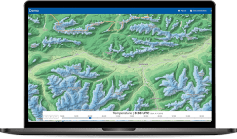
Our solution for a simple and graphically appealing presentation of weather data is the MetGIS Pro+ weather dashboard. This innovative tool provides clear and elegant visual representations of various weather variables, eliminating the need for programming expertise or specialized meteorological knowledge. It offers a comprehensive overview of the current weather situation, enabling users to make informed decisions quickly and efficiently.
Convince yourself of the quality and possibilities of our weather dashboard by taking a look at our online demo. MetGIS Pro+ is your ready-to-use solution for snow cover and fresh snow mapping – simple, efficient and effective.

A picture is worth a thousand words – and our interactive demonstration illustrates the advantages of MetGIS Pro+.
Test the dashboard for selected regions and gain comprehensive insight into the functionality of the MetGIS weather dashboard.
You can integrate the MetGIS snow cover and fresh snow information into your application via our Maps API. Available layers are:
The MetGIS Maps API enables an exceptional graphical representation of high-resolution weather data from narrowly defined areas to large regions. Users can get a quick and accurate spatial overview of a wide range of weather parameters. MetGIS snow maps – your key to precise and detailed snow information displayed on maps.
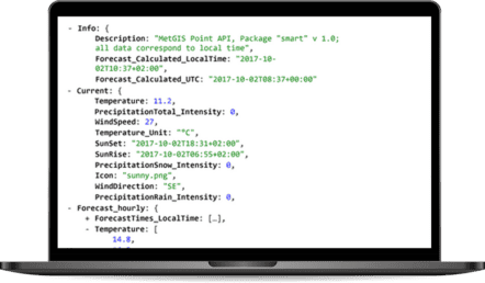
The MetGIS Point API provides you with forecasts for a wide range of weather parameters for any point in the world. We offer a special winter package specifically for snow and winter, which contains the following variables in addition to the classic weather parameters:
For the fresh snow parameter, we also provide historical weather data in high resolution via our Hist API.
 Outdoor industry
For tourism, expeditions, ski resorts, slope management and anyone involved with snow and mountains.
 Energy
For weather-optimized solutions in the energy sector, e.g. the management of power lines, as well as related software and apps.
 Other sectors
For all industries whose business success depends on weather and snow during the cold season and/or in high mountain regions.
Do you have questions about our services or any other questions, simply fill out the contact form or send us an e-mail.
We also look forward to your call.

Meteorologe, Entwickler des Designs des MetGIS Prognosesystems
Curriculum vitae
This will close in 0 seconds
This will close in 0 seconds