MetGIS FAQ
Questions and answers about weather, APIs, weather alerts and MetGIS Pro+.

Questions and answers about weather, APIs, weather alerts and MetGIS Pro+.
The Frequently Asked Questions (FAQ) section of MetGIS is regularly updated and expanded to address your inquiries. However, if you still have a question, please contact us at any time.
We look forward to your inquiry and will be happy to assist you.

What does MetGIS stand for?
“Met” stands for meteorology and “GIS” is the abbreviation for Geographic Information System.
How is a forecast created?
MetGIS is a highly advanced mathematical-physical model for global weather forecasting that utilizes precise location data. Through years of international development work with project partners from the USA to Switzerland and Japan, MetGIS GmbH has developed a forecasting model that, in contrast to conventional forecasts, incorporates highly detailed terrain data into the forecasting process, making it particularly suitable for applications in mountainous regions.
More information on our scientific background
How often are the MetGIS forecasts and analyses updated?
Depending on the product, the update frequency can range from every five minutes to once a day. For instance, our standard point forecasts are updated four times a day. The MetGIS historical weather database is updated daily to include the most recent data. Precipitation radar data is updated every five minutes, and weather warnings are issued every six minutes.
What is the forecast quality of MetGIS?
MetGIS is known for its high forecast accuracy in complex terrain, with all weather parameters that are strongly dependent on altitude, such as temperature, fresh snow, and wind, being particularly accurate. To ensure the highest standards of data quality, verification studies are carried out on an ongoing basis and used to make improvements.
Are there on-site training courses for MetGIS users?
The specific terms and conditions depend on the product in question. If necessary, our MetGIS experts can provide in-depth user training on-site, and are also available to answer any further questions you might have. Please don’t hesitate to contact us.
Which products are offered?
The MetGIS product range includes the following:
In which languages are MetGIS products available?
Most products are availabe in German, English and Spanish. The interactive weather dashboard MetGIS Pro+ is also offered in French and Italian.
Where is MetGIS used?
MetGIS has customers worldwide. Latin-american MetGIS customers can be found in Chile, Peru and Argentina. In Europa one focus is on the DACH region (Germany, Austria, Switzerland), but there are also users in Spain, France, Italy, the Benelux countries and the Balkans. In Asia customers come primarily from the mountainous regions of India, Pakistan, Bhutan and Kyrgyzstan.
Where can I find MetGIS brochures and advertising material?
You can find MetGIS documents under Downloads.
Is there MetGIS support if I have questions or need help?
You can reach us on weekdays during our regular office hours by calling +43-(0)1-89 09 032. Alternatively, for technical emergencies outside these hours, please contact us by e-mail at support@metgis.com.
We are committed to handling your request with the utmost care and professionalism.
What do the weather forecasts cost?
This depends very much on the specific services that are ordered. Some of the prices can be found on our website, in the MetGIS Webshop or in the price overview.
Who are the target groups?
Our weather information are used by private customers (hikers, mountain sports enthusiasts, etc.) as well as by state institutions and companies.
For example, we supply the energy sector, traffic control centers, mines, avalanche warning services, expedition and trekking tour operators, ski resorts, cable car companies and even national weather services. The forecasts are also suitable for the tourism industry, event organizers, agricultural businesses, insurance companies and the film industry .
What are the latest developments at MetGIS?
You can find information about our latest developments on our blog.
Are forecasts for locations higher than the Earth’s surface possible?
Yes, this is possible.MetGIS is capable of generating forecasts for both points close to the earth’s surface and air layers several thousand meters above it. These forecasts are relevant for aviation and other fields.
Where was the product developed?
The product was developed in Vienna (as a spin-off of the University of Vienna).
Where do you get the data from?
The input data for the MetGIS calculations originate from various numerical weather forecast models, including the Global Forecast System (GFS) by the National Centers for Environmental Prediction (NCEP), operated by the United States’ National Weather Service (NWS), and the Icosahedral Non-hydrostatic, Numerical Weather Prediction (ICON-NWP) model by the Deutscher Wetterdienst (German national weather service). In turn, these models rely on observations from key global weather stations, as well as data from satellites, weather balloons (radiosondes), ships, buoys, and airplanes, among others.
Do you work directly with station data?
MetGIS utilizes the data from weather stations for the development and testing of its algorithms, as well as for the verification of the generated weather forecasts. For our day-to-day operations, we use numerical weather prediction models from external providers, which are among other things based on observation data.
What does API stand for?
API is the abbreviation for “Application Programming Interface”. The MetGIS weather APIs provide weather data in standardized formats that can be used automatically by applications such as plug-ins or websites.
What does it mean that weather data can be integrated into customer websites and apps via MetGIS Weather APIs?
Websites and mobile applications can use HTTP requests to retrieve weather data from MetGIS servers and integrate it into their own infrastructure. This allows the design of your homepage to remain unchanged while easily incorporating MetGIS data.
What does API Key Management mean?
The API Key Management Tool can be used to retrieve all information associated with the API keys, such as monthly access figures.
For which locations can forecasts be queried?
The forecast can be queried worldwide, not only for the earth’s surface, but also for several kilometers above it (important for aviation). You simply enter the coordinates and the altitude and then you receive your weather parameters with a resolution of up to 30 meters via the API.
Which variables and data do I receive via the Point API?
You receive numerical data. Parameters, forecast period, time resolution (e.g. hourly weather, daily values), short forecast texts – chosen by you. The data is available to you via a JSON file output.
How can you be reached personally?
The MetGIS team can be reached on weekdays from 9.00 a.m. to 5.00 p.m. on +43 1 890 90 32.
Calls outside these hours, video conferences or personal meetings at our office in Vienna or at your premises are no problem, provided you let us know in advance.
Can I test your weather data in advance?
Of course. You are welcome to test our weather API without obligation and convince yourself of the simple integration and our reliable weather data.
To obtain a Developer API Key, please follow these steps or contact us.
What is your weather data based on?
MetGIS has developed its own multi-verified weather algorithms that combine precise terrain data with millions of measurements from ground-based weather stations, radar, satellites, weather balloons, weather buoys and aircraft. The result is a highly accurate weather analysis and forecast.
What exactly is an API call?
An API call is a data retrieval from our API. This takes place via an https request. The MetGIS Server returns a JSON file. For easy data handling our JSON files contain all requested weather data for one or more locations. Individual queries for different time periods or parameters are not necessary.
UTC and time zones: How does it work?
The MetGIS Point API makes time zones a no-brainer. While time information usually has to be converted from UTC to local time (including summer/winter time), we convert your data automatically. All time information in the JSON files refers to the local time of the location for which the weather data was requested and transmitted.
What weather parameters are available?
We offer a large number of standard parameters as well as many special parameters for specific industries (e.g. wet bulb temperature, global radiation).
Please refer to the price list for current prices.
Do you also offer weather icons?
Weather icon are used to graphically describe weather (combinations of snowfall/rain/clouds/sun, etc.). MetGIS is happy to provide a weather symbol dataset to paying customers at no additional cost.
How do I keep control of my API accesses?
Our API monitoring tool (accessible with your customer login) allows you to view your packages and statistics at a glance. You will also receive email alerts before you run out of API calls
How do I get a customer account and what are its benefits?
You create a customer account when you order a free API key for developers or at the latest when you make your first purchase in the webshop. Your account will make it easier for you to make future purchases, manage your orders, reset your password, and view your order history.
May I cache the weather data?
Data caching is only allowed in certain data packages, and then only with the explicit permission of MetGIS.
If caching is unavoidable for your planned application, please contact us and we will work with you to find a solution.
What does TMS stand for?
The MetGIS Tile Map service is a web service, to display digital maps of meteorological data based on “tiles” (“rectangular” sections of maps). Forecasts are presented in excellent form and great detail (less than 100 m resolution) in the form of zoomable forecast maps.
Can I test your weather layers in advance?
For sure!
You are welcome to test our API without obligation and convince yourself of the simple integration and impressive presentation of our weather data. To obtain a Developer API Key, please follow these steps or get in touch with us.
What weather parameters do you offer?
For the weather layer we currently offer the following parameters: Temperature, precipitation, new snow (also total amount within the next 24, 48 and 72 hours), sunshine duration, wind, cloud cover and snow cover information. If you require further parameters, please contact us at any time.
What are tiles and what is an API call?
An API call enables access to a “weather tile“. This corresponds to a 256×256 pixel segment of the weather map for a specific point in time.
Depending on the device, a map on the screen consists of approx. 15-20 Tiles.
What forecast periods do you offer?
Our weather layer are currently calculated for the next 72 hours with a time resolution of 3 hours.
This meets the requirements of most customers.
We are also happy to calculate longer forecast periods for you.
How do I retrieve data for individual locations?
If you use Point API prediction data for specific points/coordinates, the MetGIS Point API is ideal for you. Historical weather data can be accessed via the Hist API.
How do I get a customer account and what use is it to me?
You create a customer account when you order a free API key for developers or at the latest when you make your first purchase in the webshop. Your account will make it easier for you to make future purchases, manage your orders, reset your password, and view your order history.
How do I keep control of my API accesses?
Our API monitoring tool (accessible with your customer login) allows you to view your packages and statistics at a glance. You will also receive email alerts before you run out of API calls
What kind of weather parameters do you offer?
Temperature, precipitation, fresh snow, wind direction and strength, relative humidity, cloud cover, sunshine duration and global radiation. Further parameters are available on request.
How much does it cost to get historical weather data?
The cost of the weather data depends, among other things, on the temporal resolution of the data and the number of weather parameters and data years required. For details on the costs, please refer to our price overview.
How does the historical weather data from MetGIS differ from free data?
Many free APIs interpolate using very coarse grids (as an example 100km resolution). With MetGIS, the data is processed with special downscaling methods. This means that historical weather with a resolution of 1 km is possible. The data is therefore much more detailed and provides a solid basis.
How far back in time do you provide the weather data?
MetGIS currently offers weather data for up to 10 years in the past. Due to climate change, the use of older weather data makes little sense for many applications (AI training, mean and extreme value formation). However, we can supply older data if required. You can find a detailed overview on the MetGIS Hist API page.
How can you be reached personally?
The MetGIS team can be reached on weekdays from 9.00 a.m. to 5.00 p.m. on +43 1 890 90 32.
Calls outside these hours, videoconferences, or face-to-face meetings at our Vienna office or at your premises are no problem, as long as you let us know in advance.
What is your weather data based on?
MetGIS has developed its own multi-verified weather algorithms that combine precise terrain data with millions of measurements from ground-based weather stations, radar, satellites, weather balloons, weather buoys and aircraft. The result is a highly accurate weather analysis and forecast.
What exactly is an API call?
An API call is a data retrieval from our API. This takes place via an https request. The MetGIS Server returns a JSON file. For easy data handling our JSON files contain all requested weather data for one or more locations. Individual queries for different time periods or parameters are not necessary.
How do I get a customer account and what use is it to me?
You create a customer account when you order a free API key for developers or at the latest when you make your first purchase in the webshop.
Your account will make it easier for you to make future purchases, manage your orders, reset your password, and view your order history.
How do I keep control of my API accesses?
Our API monitoring tool (accessible with your customer login) allows you to view your packages and statistics at a glance.
You will also receive email alerts before you run out of API calls.
I want to stay mobile. Can I get weather information by email or SMS?
Yes. MetGIS will send you the requested weather data by email or SMS.
For more information on this topic, please contact us.
What is the difference between the PDF weather report and the Ski Cockpit?
The difference are special parameters for ski centers, otherwise it is identical to the PDF weather reports. We have developed the Ski Cockpit especially for ski resort operators: It includes a general weather overview, detailed wind and precipitation data and precise wet bulb temperature forecasts. This allows you to make snowmaking and slope preparation decisions on a professional basis. The benefits are many: from more efficient use of electricity and water (cost and environmental) to better snow quality and better planning of the team’s work in preparing the slopes.
Is it possible to request the Ski Cockpit and the PDF weather reports for specific regions or locations?
The weather forecasts are not generalized for a region, but for specific locations/coordinates (e.g. mountain station, middle station, slopes with snow machines). The calculation is based on your desired locations. You will get a PDF page with precise forecasts for each location.
What is MetGIS Pro+?
MetGIS Pro+ provides clear and elegant visual representations of various weather variables, eliminating the need for programming expertise or specialized meteorological knowledge.
All information is presented graphically, allowing you to leverage MetGIS’ extensive knowledge and experience in an intuitive GUI interface. MetGIS Pro+ is your out-of-the-box solution for weather data – simple, efficient and effective. Convince yourself of the quality and power of our weather dashboard by trying our online demo.
Is it possible to order a specific section?
The MetGIS experts are able to create graphical user interfaces (GUIs) for individually requested areas. For more information on this topic simply fill out the contact form or contact us per e-mail.
We also look forward to your call (+43 (0)1 890 90 32).
How quickly is a customized project available?
The basic product (relatively coarse resolution maps from anywhere in the world) is available fairly quickly.
If customization is required (higher resolution or detailed geographic background maps), it may take several weeks before the product is available.
Can the packages described be supplemented/modified?
Our packages are based on the requirements and experience of numerous international expeditions. Should you wish to extend the services included or the time period, we will be happy to meet your needs at an additional charge.
How long before my expedition should I order the weather services?
We want to give you the best possible service and therefore reserve time for personal consultations.
We therefore recommend booking several weeks in advance. If this is not possible, we will do our best to find a suitable solution for you, even at very short notice.
At what times are you available for consultations?
We prefer to offer consultations between 10 a.m. and 6 p.m. CET. Other time slots are possible by arrangement. To ensure the best possible quality of advice, we recommend arranging an appointment 24 hours in advance.
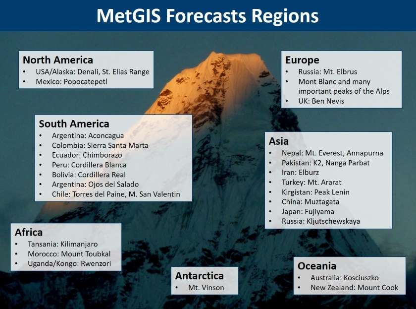
For which regions do you offer your weather services and forecast maps?
Our prognose maps are currently available for over 200 regions: from Nepal to Greenland, from Antarctica to the Seven Summits. All other services are generally available for any coordinate.
Internet reception and weather services - What do I need to bear in mind?
Internet connections are rare or cost-intensive in remote regions. All our online services are therefore optimized for this purpose. Please understand that we cannot accept responsibility for any kind of technical failure.
Why are your packages for expeditions so inexpensive?
In our experience, personal advice is often offered, booked (and paid for!) on a daily basis for the entire duration of the expedition, but is then only partially utilized. This is why we give priority to personal advice in important and critical phases of the expedition. We are happy to pass this cost advantage on to you.
I regularly take part in expeditions. Do you offer special conditions?
We offer discounts when booking weather services for several expeditions per year. Travel agencies also have the option of all-inclusive annual packages. Please contact us in this regard.
In which regions have you already supervised expeditions?
MetGIS weather services have already proven themselves many times internationally: On expeditions from the Himalayas to Greenland to Patagonia.
What services do you offer in this area?
Because consulting and expert witness services are highly individualized, there are no pre-defined products.
Simply send us your request and we will provide you with an individual offer tailored to your needs.
We meet all the requirements to operate as an engineering company and provide you with our entire expertise in the field of weather.
Do you have questions about our services or any other questions, simply fill out the contact form or send us an e-mail.
We also look forward to your call.
About us
Legal matters

Meteorologe, Entwickler des Designs des MetGIS Prognosesystems
Curriculum vitae
This will close in 0 seconds
This will close in 0 seconds


