Infrastructure and agriculture
Weather data for agriculture and infrastructure – comprehensive meteorological data for your application

Weather conditions have a direct impact on the agricultural and infrastructure sectors, which are exposed to the elements. These sectors are vulnerable to the unpredictability of weather, which can have a direct impact – from crop loss to risk to human life. MetGIS has expertise in this field and provides a comprehensive portfolio of weather applications and services. These services give our clients a strategic advantage in planning and risk management.


The availability of reliable meteorological data is paramount for the effective planning and execution of operations in large-scale construction sites and opencast mines. MetGIS offers specialized weather data services that provide a distinct competitive advantage by enabling organizations to strategically plan maintenance operations, enhance efficiency, and optimize the safety of personnel and equipment. Discover how MetGIS can enhance your operations with professional weather data.
MetGIS is rooted in scientific principles, underscoring the significance of precise data in agriculture, particularly within the expanding domain of smart farming. Our comprehensive offerings encompass support for the planning and execution of sowing, irrigation, fertilization, and harvesting processes. By leveraging our expertise and leveraging weather-related solutions, our clients can achieve sustainable benefits.

In the transport and logistics sector, precise weather data is essential for ensuring safety and efficient processes, as both road and rail are exposed to the weather. MetGIS offers a range of weather products and services that support various applications, including traffic control (e.g., for winter service and heavy rain situations), weather-dependent route planning, smart traffic (intelligent traffic flow optimization) and IoT approaches in vehicle technology.
Get more information on how MetGIS’ specialized services and products can benefit your organization!
![]() Premium weather data: up to 30 m resolution
Premium weather data: up to 30 m resolution
We are proud to combine innovative weather models with precise terrain data, which is integral to the high quality of our forecasts. This claim is supported by verification studies that have been conducted on several continents since 2007.
 Expert hotline
We don’t hide behind contact forms or chatbots! If you would like to talk to us, simply call us directly. Our meteorologists and IT professionals will be happy to help you on +43 1 890 90 32.
 Test without obligation with Developer Key
See the precision of our weather data for yourself how easy it is to integrate it into your website, app or business application. Follow these steps to test our API for 30 days at no obligation.
PRECISE WEATHER INFORMATION
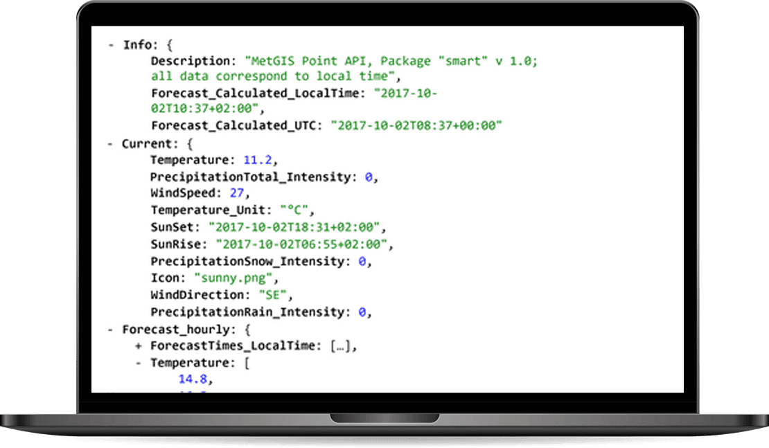
The MetGIS Point API is a reliable and powerful solution for querying point-based weather data. Via the API we offer a variety of weather parameters, which are available in different output formats.
The API can be integrated into your application quickly and easily.
HIGH-RESOLUTION WEATHER LAYERS
Our Maps API makes it easy to integrate weather data into external information systems and platforms that are based on the Tile Map Service (TMS) standard.
The weather information can thus be placed as a “color layer” over background maps such as Google Maps or OpenStreetMap.
HISTORICAL WEATHER DATA WITH THE HIGHEST PRECISION

MetGIS provides an extensive set of historical weather data.
To generate the data, we went beyond the usual standard.
Our approach not only includes global weather reanalysis models, but also integrates information from regional simulation models and measurement series from certified weather stations.
WEATHER FORECASTS FOR THE FUTURE

The MetGIS Long Range Forecast API relies on ensemble modeling. For this purpose, different forecasts (“ensemble members”) are used and compared with each other. The accuracy of weather predictions is directly related to the number of ensemble members who predict a certain weather situation.
MetGIS is able to recognise trends and forecast probabilities, and make these available to you.
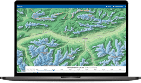
High-resolution and interactive

MetGIS Pro+ is your ready-to-use solution for weather data – simple, efficient and effective. This interactive, advanced dashboard bundles high-resolution weather and snow information into one easy-to-use application. All information is presented graphically, allowing you to leverage MetGIS’ extensive expertise and experience in an intuitive GUI interface.
Daily weather reports in your email inbox

The MetGIS Weather PDF Report is a straightforward, ready-to-use solution that automatically notifies you on a one-time or recurring basis regarding the weather forecast for the coming days. It presents all significant meteorological details in a compact, graphically designed PDF format, incorporating embedded forecast information in a compact, easy-to-understand layout. It enables rapid and straightforward comprehension of current and future weather conditions.
Do you have questions about our services or any other questions, simply fill out the contact form or send us an e-mail.
We also look forward to your call.

Meteorologe, Entwickler des Designs des MetGIS Prognosesystems
Curriculum vitae
This will close in 0 seconds
This will close in 0 seconds