Avalanche warning service
Weather data for avalanche services that you can rely on

At MetGIS, we are proud to offer a comprehensive range of meteorological products, including sophisticated weather APIs, interactive maps, and user-friendly weather dashboards. Our tools are designed to provide avalanche warning services with a stable and accurate database. MetGIS thus makes an important contribution to the production of high-quality avalanche reports.

The avalanche warning service in Tyrol was the first to utilize the high-resolution MetGIS weather data in the designated avalanche area. As the reputation of the data’s exceptional quality has gained international recognition, MetGIS data has become a preferred solution for numerous users worldwide.

As soon as the first snowfall occurs in the mountains, avalanche risk becomes a concern, and these events often result in severe accidents. Over time, regional and national avalanche warning services and specialized software applications have been developed to mitigate this risk. These resources provide crucial information to assist ski tourers in preparing for their mountain excursions. If the risk is deemed too high, alternative summits or routes can be selected, or the tour can be canceled altogether. In many regions, local avalanche commissions make critical decisions regarding road closures in dangerous situations. Avalanche forecasters require a combination of expertise, knowledge of current snowpack structures, and access to current weather data to prepare accurate reports.
This data is used directly and incorporated into relevant calculation models. Accurate and reliable weather data is paramount, as incorrect information can have serious consequences. For this reason, the data base must be highly accurate and reliable.
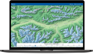
MetGIS Pro+ has been the most widely adopted MetGIS tool for avalanche warning services. The interactive dashboard provides a comprehensive overview of the large-scale weather situation in the target area, with the option to zoom in for detailed analysis. Additionally, users can access weather data for the next 10 days for any specified location with a simple click. The dashboard features vital weather parameters crucial for avalanche warnings, including temperature, precipitation (rain and fresh snow), wind, cloud cover, and sunshine duration. Users can access high-resolution maps of the current snow cover, derived from satellite and model data, to support informed decision-making.

Discover how MetGIS’s advanced weather solutions can streamline the process of creating avalanche bulletins. For more information, please visit our Snow and Winter page. Don’t hesitate to contact us for a demonstration or further details.

Avalanche warning services utilize a variety of methods to disseminate crucial information. Many of them operate their own avalanche simulation models or employ visualization systems and web platforms, which enable the public to access vital data. Our APIs provide seamless integration with these services, ensuring a streamlined flow of high-quality weather data. In addition to the parameters featured on our dashboard, our APIs offer a comprehensive range of additional information, particularly relevant during the cold season. This includes parameters such as snow line, zero degree line, new snow density, freezing rain, and wet bulb temperature. Additionally, we offer APIs for high-resolution terrain data (30-meter x 30-meter grid) containing information on lake height, slope inclination, and slope orientation. Combined with weather data (especially wind and fresh snow), our APIs enable the derivation of avalanche risk information even in confined spaces.


Professional API with ultra-precise weather forecasts for the whole world, accurate to 30 meters.
High-resolution weather layers for existing maps (e.g. Google Maps) or area forecasts.

Weather data from the past with extremely high resolution.
Do you have questions about our services or any other questions, simply fill out the contact form or send us an e-mail.
We also look forward to your call.

Meteorologe, Entwickler des Designs des MetGIS Prognosesystems
Curriculum vitae
This will close in 0 seconds
This will close in 0 seconds


