AGRICULTURE AND SMART FARMING
Weather precision for top agricultural performance with MetGIS

Weather is the backbone of agriculture. Understanding and interpreting weather parameters is the difference between success and failure in agriculture. When is the best time for watering? How will the weather develop in the coming weeks and affect planting or harvesting? MetGIS agricultural weather solutions provide you with a solid database to answer these and many other questions.


As your agricultural weather expert, MetGIS offers a wide range of solutions, from APIs to a comprehensive weather dashboard. Prepare for the uncertainties of climate change and focus on your farming business with reliable data from MetGIS.
Whether you practice traditional agriculture, specialize in smart farming, work in greenhouses, or grow wine, MetGIS provides weather parameters tailored to your application based on our scientific background.
Let’s optimize your agricultural processes together!
Discover how MetGIS can help you reduce your crop losses and increase your yields.
If you are interested in a demonstration of MetGIS products and services, please contact us for a demonstration or further information.

![]() Premium weather data: up to 30 m resolution
Premium weather data: up to 30 m resolution
We are proud to combine innovative weather models with precise terrain data, which is integral to the high quality of our forecasts. This claim is supported by verification studies that have been conducted on several continents since 2007.
 Expert hotline
We don’t hide behind contact forms or chatbots! If you would like to talk to us, simply call us directly. Our meteorologists and IT professionals will be happy to help you on +43 1 890 90 32.
 Test without obligation with Developer Key
See the precision of our weather data for yourself. And how easy it is to integrate into your website, app or business application. Follow these steps to test our API for 30 days without obligation.
PRECISE WEATHER INFORMATION
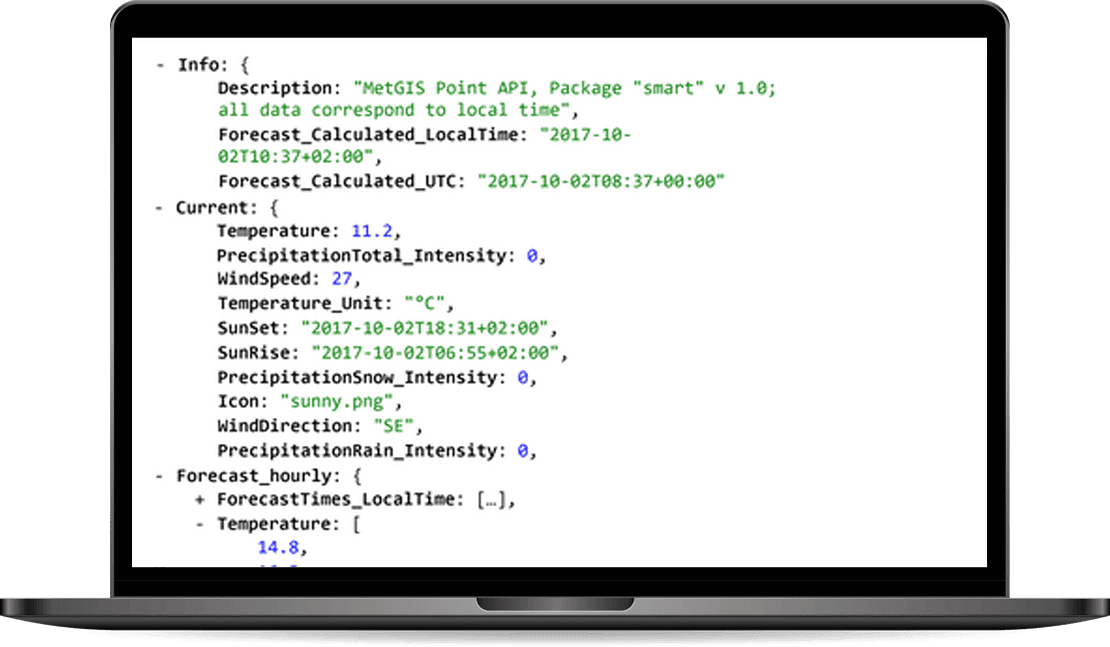
The MetGIS Point API is a reliable and powerful solution for querying point-based weather data. Via the API we offer a variety of weather parameters, which are available in different output formats.
The API can be integrated into your application quickly and easily.
HIGH-RESOLUTION WEATHER LAYERS
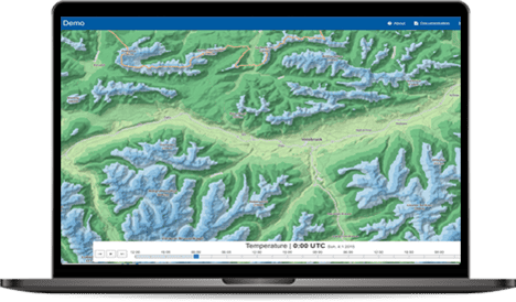
Our Maps API makes it easy to integrate weather data into external information systems and platforms that are based on the Tile Map Service (TMS) standard.
The weather information can thus be placed as a “color layer” over background maps such as Google Maps or OpenStreetMap.
HISTORICAL WEATHER DATA WITH THE HIGHEST PRECISION

MetGIS provides an extensive set of historical weather data.
To generate the data, we went beyond the usual standard.
Our approach not only includes global weather reanalysis models, but also integrates information from regional simulation models and measurement series from certified weather stations.
WEATHER FORECASTS FOR THE FUTURE

The MetGIS Long Range Forecast API relies on ensemble modeling. For this purpose, different forecasts (“ensemble members”) are used and compared with each other. The accuracy of weather predictions is directly related to the number of ensemble members who predict a certain weather situation.
MetGIS is able to recognise trends and forecast probabilities, and make these available to you.
High-resolution and interactive

MetGIS Pro+ is your ready-to-use solution for weather data – simple, efficient and effective. This interactive, advanced dashboard bundles high-resolution weather and snow information into one easy-to-use application. All information is presented graphically, allowing you to leverage MetGIS’ extensive expertise and experience in an intuitive GUI interface.
Daily weather reports in your email inbox

The MetGIS Weather PDF Report is a straightforward, ready-to-use solution that automatically notifies you on a one-time or recurring basis regarding the weather forecast for the coming days. It presents all significant meteorological details in a compact, graphically designed PDF format, incorporating embedded forecast information in a compact, easy-to-understand layout. It enables rapid and straightforward comprehension of current and future weather conditions.
Do you have questions about our services or any other questions, simply fill out the contact form or send us an e-mail.
We also look forward to your call.

Meteorologe, Entwickler des Designs des MetGIS Prognosesystems
Curriculum vitae
This will close in 0 seconds
This will close in 0 seconds