OPEN PIT MINES AND LARGE CONSTRUCTION SITES
Weather forecasts for efficiency and safety

Open-pit mines and large construction sites are particularly dependent on the weather. Weather conditions significantly impact safety for people and equipment. Parameters include high or low temperatures, heavy rain, snowfall, thunderstorms, storms, strong sunlight, and high humidity. Accurate weather forecasting is essential for minimizing economic losses due to operational shutdowns caused by extreme weather, ensuring minimal downtime. Furthermore, the ability to plan maintenance and servicing operations, as well as personnel deployment, is enhanced. This ultimately leads to more efficient resource utilization, increased safety, and enhanced productivity. In light of climate change, effective weather planning is of great importance. MetGIS weather data for open pit mines provides a wide range of products and services to support this critical need.
 Efficient planning of all activities relating to your project
 Reduction of accident risk and increase in team safety
 Plannable downtimes, maintenance and blasting
 Compliance with safety standards on transport routes
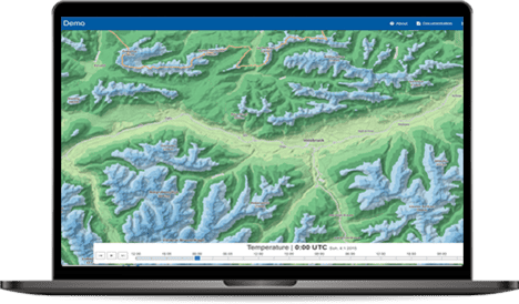
Our solution for a simple and graphically appealing presentation of weather data is the MetGIS Pro+ weather dashboard. This innovative tool provides clear and elegant visual representations of various weather variables, eliminating the need for programming expertise or specialized meteorological knowledge. It offers a comprehensive overview of the current weather situation, enabling users to make informed decisions quickly and efficiently. Convince yourself of the quality and possibilities of our weather dashboard by taking a look at our online demo.

A picture is worth a thousand words – and our interactive demo speaks volumes about the benefits of MetGIS Pro+. Test the dashboard for mining regions in South America and gain a comprehensive insight into the functionality of the MetGIS weatherdashboard.
By analysing historical weather data, it is possible to identify correlations between weather conditions and a company’s performance, leading to enhanced planning and increased success.


Legal requirements, certifications and corporate policies are becoming increasingly stringent. It is therefore necessary to rely on professional weather forecasts and parameters to meet these requirements.
Especially at high altitudes and during the winter months, heavy snowfall or avalanches can lead to costly disruptions.
Forecast snowfall with our weather applications and plan ahead to avoid safety risks and downtime. The weather parameters wind and snowfall allow you to assess and plan for the risk of avalanches.
Strong winds in particular can be devastating and have a major impact on the environment. It can also have a negative impact on the health of your team. Plan your activities to avoid these hazards.
![]() Ultra-precise weather forecasts (up to 30 meter resolution!)
Ultra-precise weather forecasts (up to 30 meter resolution!)
Precise and accurate predictions are the basis for efficiency and safety. That’s why we have optimized our algorithms to deliver a resolution of up to 30 meters! The combination with detailed terrain data leads to even better forecasts in mountainous regions such as the Andes.
 Easy-to-use solutions and Spanish advice
Our solutions for the mining industry are designed for both meteorologists and unskilled personnel to make better decisions on weather-related issues. Thanks to our Spanish-speaking team, we can help, advise and train you by phone, video call or in person at your office or directly at your mine.
 More than 10 years of experience in the Latin American mining industry
MetGIS has been operating successfully in Latin America for more than a decade. This means that we not only know the needs of the mining industry, but also the weather-related challenges in the Andean region. Our solutions and our customers benefit directly from this.
PRECISE WEATHER INFORMATION
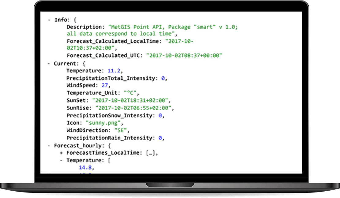
The MetGIS Point API is a reliable and powerful solution for querying point-based weather data. Via the API we offer a variety of weather parameters, which are available in different output formats.
The API can be integrated into your application quickly and easily.
HIGH-RESOLUTION WEATHER LAYERS
Our Maps API makes it easy to integrate weather data into external information systems and platforms that are based on the Tile Map Service (TMS) standard.
The weather information can thus be placed as a “color layer” over background maps such as Google Maps or OpenStreetMap.
HIGH-RESOLUTION WEATHER LAYERS

MetGIS provides an extensive set of historical weather data.
To generate the data, we went beyond the usual standard.
Our approach not only includes global weather reanalysis models, but also integrates information from regional simulation models and measurement series from certified weather stations.
WEATHER FORECASTS FOR THE FUTURE

The MetGIS Long Range Forecast API relies on ensemble modeling. For this purpose, different forecasts (“ensemble members”) are used and compared with each other. The accuracy of weather predictions is directly related to the number of ensemble members who predict a certain weather situation.
MetGIS is able to recognise trends and forecast probabilities, and make these available to you.
High-resolution and interactive

MetGIS Pro+ is your ready-to-use solution for weather data – simple, efficient and effective. This interactive, advanced dashboard bundles high-resolution weather and snow information into one easy-to-use application. All information is presented graphically, allowing you to leverage MetGIS’ extensive expertise and experience in an intuitive GUI interface.
Daily weather reports in your email inbox

The MetGIS Weather PDF Report is a straightforward, ready-to-use solution that automatically notifies you on a one-time or recurring basis regarding the weather forecast for the coming days. It presents all significant meteorological details in a compact, graphically designed PDF format, incorporating embedded forecast information in a compact, easy-to-understand layout. It enables rapid and straightforward comprehension of current and future weather conditions.
Increase the profitability of your business
Achieve your financial goals more easily
Protect your staff from weather-related risks
Reduce the risk of accidents involving employees and equipment
Identify risks of flooding, avalanches and landslides at an early stage
Comply with health and safety guidelines
Improve your local observation data and coarse-resolution models with highly accurate predictions
Better decisions and reports for management
Plan your operations more efficiently
Schedule maintenance and blasting depending on the weather conditions
Safety for your team
Optimize your supply chain
Monitor access roads and take appropriate action
If available, monitor your local airport
Do you have questions about our services or any other questions, simply fill out the contact form or send us an e-mail.
We also look forward to your call.
Klicke hier, um Ihren eigenen Text einzufügen

Meteorologe, Entwickler des Designs des MetGIS Prognosesystems
Curriculum vitae
This will close in 0 seconds
This will close in 0 seconds