Tourism and outdoor
High-resolution weather data for the tourism industry

MetGIS offers a comprehensive suite of solutions tailored to meet the needs of the tourism industry. Our offerings include weather forecasts and dashboards providing up-to-date weather information, ideal for managing visitor flow. We also specialize in integrating weather data into tourism-related websites and applications. In addition to forecasting, our solutions utilize high-resolution historical weather data to support the development of AI applications and climate data to assist tourists in selecting the optimal travel time to their desired destination.
 Easy data retrieval via APIs or our customized weather dashboard
 High accuracy and specialization in mountain regions
 Forecasts for many parameters 10 days in advance or even long-term
 High-resolution historical weather data, perfect for AI applications
The tourism industry is extremely diverse and offers a wide range of services. MetGIS provides a comprehensive range of weather data and services to provide you with the right solution. Below are some applications in which MetGIS products can support the tourism industry:


Our weather APIs are designed to seamlessly integrate high-quality weather data into a variety of platforms and services, including websites, mobile applications, and information displays found in tourist information offices, accommodation providers, tourist attractions and other tourism-related services. In addition to numerical data, we offer ready-to-use, interactive solutions that combine forecast maps with weather reports for any location and map point.
In many places, managing visitor flows with the help of precise weather forecasts is an increasingly important topic. Special offers can be provided and promoted for certain weather conditions, e.g. in the event of bad weather, visitors can be redirected to indoor attractions.
Weather data can also be used to forecast visitor flows. In addition to meteorological forecasts, historical weather data is often used to train AI models. MetGIS offers this data for Central Europe in very high spatial and temporal resolution.


MetGIS provides climate data and tables for common weather parameters including temperature, precipitation, fresh snow, cloud cover and wind. In addition to average values, the software offers maximum and minimum values on a monthly and daily basis, with precise adaptation to surrounding terrain and altitude. This enables vacationers and tour operators to access reliable weather information for specific months or weeks, even in mountainous regions. In contrast, competing products typically offer only average and maximum values relevant to cities or broader regions.
Weather is often a safety-relevant factor, especially when it comes to planning itineraries for tourists and outdoor activities.
MetGIS offers specialized versions of its weather API to predict weather conditions along routes and tours, considering factors such as start time and assumed travel speed.
This feature is particularly beneficial for route planning, especially in contexts such as extended hiking, alpine activities like summit ascents, ski tours, cycling and mountain bike tours and motorized tours.


MetGIS offers comprehensive support for travel agencies at various stages of (mountain) travel, from planning to execution. Thanks to the worldwide availability of precise weather data, even in remote areas, MetGIS can use forecasts to prevent the trip from potentially ending in a dead end. MetGIS also has the option of sending weather warnings with individually definable threshold values and can use climate data to help determine the best time to travel to certain areas in terms of weather.
Ultra-precise weather forecasts (up to 30 meters resolution)
Instead of conventional, less accurate predictions!
 Specially developed & optimized for mountain regions
Thanks to extremely detailed mountain and terrain data!
 Excellent service: faster, more flexible and more reliable
Feel free to compare us with other providers!
PRECISE WEATHER INFORMATION
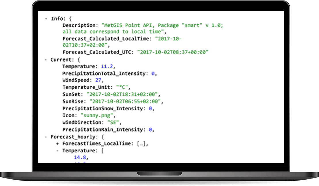
The MetGIS Point API is a reliable and powerful solution for querying point-based weather data. Via the API we offer a variety of weather parameters, which are available in different output formats. The API can be integrated quickly and easily so that you can use it for your application.
HIGH-RESOLUTION WEATHER LAYERS
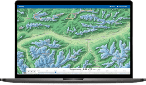
Our Maps API makes it easy to integrate weather data into external information systems and platforms that are based on the Tile Map Service (TMS) standard. The weather information can thus be placed as a “color layer” over background maps such as Google Maps or OpenStreetMap.
HISTORICAL WEATHER DATA WITH THE HIGHEST PRECISION

MetGIS has an extensive set of historical weather data. To generate the data, we went beyond the usual standard. Our approach not only includes global weather reanalysis models, but also integrates information from regional simulation models and measurement series from certified weather stations.
WEATHER FORECASTS FOR THE FUTURE

The MetGIS Long Range Forecast API relies on ensemble modeling. For this purpose, different forecasts (“ensemble members”) are used and compared with each other. The accuracy of weather predictions is directly related to the number of ensemble members who predict a certain weather situation.
MetGIS is able to recognise trends and forecast probabilities, and make these available to you.
High-resolution and interactive
MetGIS Pro+ is your ready-to-use solution for weather data – simple, efficient and effective. This interactive, advanced dashboard bundles high-resolution weather and snow information into one easy-to-use application. All information is presented graphically, allowing you to leverage MetGIS’ extensive expertise and experience in an intuitive GUI interface.
Daily weather reports in your email inbox

The MetGIS Weather PDF Report is a straightforward, ready-to-use solution that automatically notifies you on a one-time or recurring basis regarding the weather forecast for the coming days. It presents all significant meteorological details in a compact, graphically designed PDF format, incorporating embedded forecast information in a compact, easy-to-understand layout. It enables rapid and straightforward comprehension of current and future weather conditions.
Do you have questions about our services or any other questions, simply fill out the contact form or send us an e-mail.
We also look forward to your call.

Meteorologe, Entwickler des Designs des MetGIS Prognosesystems
Curriculum vitae
This will close in 0 seconds
This will close in 0 seconds


